Håkan Nordlund
Partner Program Manager, Esri
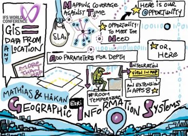
A GIS – geographic information system – is more than about making maps, printing maps or creating databases. It’s about giving better insights than in a normal relational database system. It’s another way of spotting relationships between objects that you might have missed.
Imagine a chain of supermarkets, with a service agreement for its freezers. The SLA states that repairs must start within 30 minutes. There’s been an issue with some freezers, and the service people haven’t been arriving in time. With a GIS you can start looking at what the issues might be. We can look at the road network, we can look at the traffic. You can see, based on that, the real service area in 25 minutes. In this case, it shows that many client sites are outside the areas we can actually reach within 25 minutes. Adjusting for time of day shows that spike traffic isn’t the problem, but general traffic instead – the 25 minute zone doesn’t change much. What you are left with is a real problem that needs solving – customers whose SLA you can’t meet.
What can we do? Use the GIS to look at possible service points, and calculate the best ones. In the example given, they need 19 locations to manage the SLA, not four.
Mathias Dahl
Product architect – document management and maps solutions, IFS
Here’s some other examples:
Sick notes
Recently, HR have noticed that a number of employees have been calling in sick. They can call up the employees’ seating locations on an office map. No clear pattern emerges. Then you overlay it with room temperatures. The areas the sick people are all in very cold areas. Ah-ha!
Power map
A map of power lines can show the buildings around them, the data for which can all be drawn from IFS. And you can interact with map objects as if they were IFS items – create fault reports or work orders, for example. Floor plans of buildings or factory plans are all usable in this way.
IFS’s GIS integration is quite self-contained within the IFS system. However, you will need an Esri database as well.